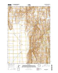
2014 Map of Mahon Creek
USGS Topo · Published 2014About this map
The Stinkingwater Mountains and the Crane Creek Mountains anchor this high-desert landscape in Harney County, Oregon. A complex network of water management features highlights the importance of every drop in this arid terrain, with numerous man-made catchments like Big Spring Reservoir, Rock Hill Reservoir, and Rector Reservoir scattered across the uplands. The terrain transitions from the prominent heights of Crowcamp Mountain down to expansive level areas such as Ritterbusch Flat and Devine Flat. Isolated water sources, including McDonald Waterhole and various springs like Riley Spring, reflect the vital infrastructure required for ranching and survival in the Oregon interior. The map also traces established routes like Crane-Buchanan Rd, which provides primary access through this remote section of the Great Basin.
Find a feature on this map
40 named features on this map. Tap any name to fly to it.
Don’t see what you’re looking for? This feature index may not catch every label — zoom into the map to look around manually.
Map Details
Editions of this 2014 Mahon Creek Map
This is the sole edition of this map. No revisions or reprints were ever made.
Other maps of this area

1955 · Burns
USGS Topo · 1:250,000

1958 · Burns
USGS Topo · 1:250,000

1959 · Burns
USGS Topo · 1:250,000

1960 · Crane
USGS Topo · 1:62,500

1968 · Venator
USGS Topo · 1:62,500
1972 · Tin Can Ridge
USGS Topo · 1:24,000

1973 · Buchanan
USGS Topo · 1:24,000

1973 · Mahon Creek
USGS Topo · 1:24,000

1973 · Carson Point
USGS Topo · 1:24,000
1977 · Bartlett Mtn
USGS Topo · 1:24,000