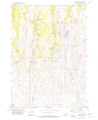
1972 Map of Tin Can Ridge
USGS Topo · Published 1977About this map
Tin Can Ridge dominates this high-desert landscape in Harney County, where a network of seasonal drainages and remote springs supported localized ranching operations in the early 1970s. The map illustrates a reliance on water management in an arid environment, centered around Hunter Ranch and the nearby Hunter Ranch Reservoir. The presence of a Corral and numerous Jeep Trails underscores the pastoral and transit-heavy nature of the terrain, while the naming of small features like Tin Can Spring and Cold Spring points to their critical importance for livestock and travellers. The hydrology is complex, with Crane Creek, Little Crane Creek, and Coyote Creek carving out the topography alongside named depressions like Cow Canyon. To the west, the Alder Creek Meadow and Alder Creek Res represent vital catchment areas, providing a clear picture of how land was utilized and navigated before more modern infrastructure changes reached this section of Oregon.
Find a feature on this map
19 named features on this map. Tap any name to fly to it.
Don’t see what you’re looking for? This feature index may not catch every label — zoom into the map to look around manually.
Map Details
Editions of this 1972 Tin Can Ridge Map
This is the sole edition of this map. No revisions or reprints were ever made.
Other maps of this area

1955 · Burns
USGS Topo · 1:250,000

1958 · Burns
USGS Topo · 1:250,000

1959 · Burns
USGS Topo · 1:250,000

1960 · Crane
USGS Topo · 1:62,500

1968 · Venator
USGS Topo · 1:62,500

1972 · Circle Bar
USGS Topo · 1:24,000

1972 · Venator
USGS Topo · 1:24,000
1972 · Dunnean
USGS Topo · 1:24,000

1973 · Mahon Creek
USGS Topo · 1:24,000

1978 · Malheur Lake
USGS Topo · 1:100,000