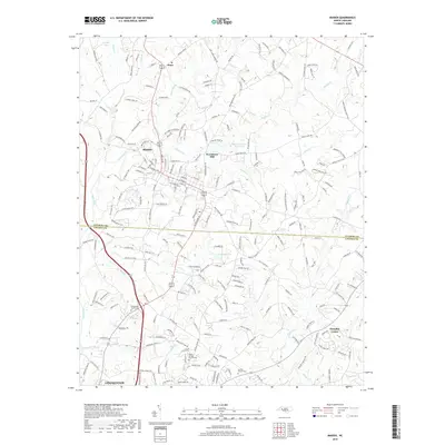
2019 Map of Maiden
USGS Topo · Published 2019About this map
The town of Maiden serves as a primary hub for this portion of the Piedmont, situated near the boundary of Catawba and Lincoln Counties. The landscape is defined by the drainage networks of Maiden Cr and Clark Creek, which historical development followed through the establishment of sites like Providence Mill. In the southern portion of the quadrangle, the community of Pumpkin Center and the outskirts of Lincolnton reflect the area's continued residential and industrial expansion. Genealogists will find significant value in the documentation of local landmarks such as McKendree Church Cem and Poplar Springs Church Cem. Water management is prominent in the landscape through features like the Maiden Water Plant Lake and Gladdens Lake, indicating the infrastructure supporting the surrounding settlements. Smaller, more localized communities such as Duan further illustrate the distribution of regional population centers beyond the main municipal boundaries.
Find a feature on this map
227 named features on this map. Tap any name to fly to it.
Don’t see what you’re looking for? This feature index may not catch every label — zoom into the map to look around manually.
Map Details
Editions of this 2019 Maiden Map
This is the sole edition of this map. No revisions or reprints were ever made.
Other maps of this area

1895 · Hickory
USGS Topo · 1:125,000

1909 · Lincolnton
USGS Topo · 1:62,500

1911 · Lincolnton
USGS Topo · 1:62,500

1914 · Gastonia
USGS Topo · 1:48,000

1916 · Gastonia
USGS Topo · 1:62,500

1953 · Charlotte
USGS Topo · 1:250,000

1954 · Charlotte
USGS Topo · 1:250,000

1960 · Charlotte
USGS Topo · 1:250,000

1962 · Charlotte
USGS Topo · 1:250,000
1970 · Lincolnton East
USGS Topo · 1:24,000