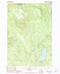
1988 Map of Maidstone Lake
USGS Topo · Published 1988About this map
Maidstone Lake and the surrounding woodlands of Essex County define this Northeast Kingdom landscape as it appeared in the late 1980s. This survey documents a transition in land use, where the timber and milling heritage of the region, represented by Browns Mill and the Walker Dam (Site), sits alongside the recreational conservation of Maidstone State Park. The eastern edge of the quadrangle follows the winding Connecticut River, which serves as the boundary between Vermont and New Hampshire near North Stratford. Higher elevations are marked by the notable summits of West Mountain and Lake Mtn, while the interior valleys are dominated by extensive wetlands like Ferdinand Bog and Granby Bog. For local historians, the location of the Brunswick Springs (Site) provides a specific coordinate for a place with deep regional significance.
Find a feature on this map
44 named features on this map. Tap any name to fly to it.
Don’t see what you’re looking for? This feature index may not catch every label — zoom into the map to look around manually.
Map Details
Editions of this 1988 Maidstone Lake Map
This is the sole edition of this map. No revisions or reprints were ever made.
Other maps of this area

1920 · Guildhall
USGS Topo · 1:62,500

1924 · Island Pond
USGS Topo · 1:48,000

1926 · Island Pond
USGS Topo · 1:62,500

1929 · Averill
USGS Topo · 1:62,500

1931 · Guildhall
USGS Topo · 1:48,000

1933 · Guildhall
USGS Topo · 1:48,000

1937 · Guildhall
USGS Topo · 1:62,500

1950 · Lewiston
USGS Topo · 1:250,000

1951 · Burke
USGS Topo · 1:62,500

1953 · Island Pond
USGS Topo · 1:62,500