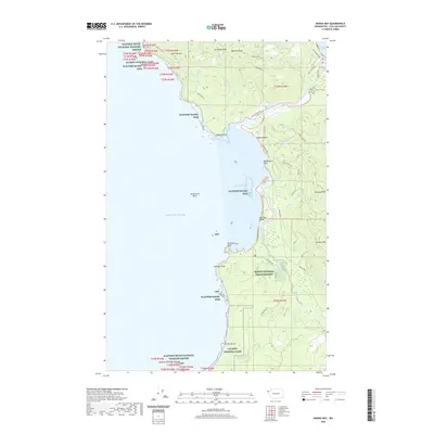
2020 Map of Makah Bay
USGS Topo · Published 2020About this map
Cape Flattery marks the northwesternmost point of the contiguous United States on this 2020 map, where the Pacific Ocean meets the entrance to the Strait of Juan de Fuca. The landscape is defined by the coastal management of the Makah National Fish Hatchery and the protected lands of Olympic National Park. The topography reveals a complex network of coastal drainages, including the Tsoo-Yess River and Waatch River, which meander through lowlands before reaching Makah Bay. Local access is provided by roads such as Cape Flattery Rd and Hobuck Rd, leading to the surf at Hobuck Beach and the southern reaches of Shi-Shi Beach. Offshore, the Flattery Rocks National Wildlife Refuge preserves numerous sea stacks and islets, including the prominent Spike Rock, illustrating the conservation priorities of this coastal frontier.
Find a feature on this map
52 named features on this map. Tap any name to fly to it.
Don’t see what you’re looking for? This feature index may not catch every label — zoom into the map to look around manually.
Map Details
Editions of this 2020 Makah Bay Map
This is the sole edition of this map. No revisions or reprints were ever made.
Other maps of this area

1935 · Ozette Lake
USGS Topo · 1:62,500

1938 · Cape Flattery
USGS Topo · 1:62,500

1942 · Ozette Lake
USGS Topo · 1:62,500

1953 · Cape Flattery
USGS Topo · 1:250,000

1956 · Ozette Lake
USGS Topo · 1:62,500
1957 · Cape Flattery
USGS Topo · 1:62,500

1963 · Cape Flattery
USGS Topo · 1:250,000

1984 · Umbrella Creek
USGS Topo · 1:24,000
1984 · Ozette
USGS Topo · 1:24,000
1984 · Makah Bay
USGS Topo · 1:24,000