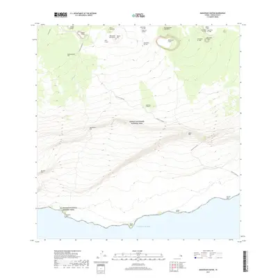
2017 Map of Makaopuhi Crater
USGS Topo · Published 2017About this map
Makaopuhi Crater and the surrounding volcanic landscape of Hawai'i Volcanoes National Park dominate this 2017 survey. The terrain is a complex record of active geology, documenting numerous eruptions including the Lava Flow of 1840, the Lava Flow of 1923, and the more recent Lava Flow of 1972. These flows are interspersed with prominent shields and craters like Mauna Ulu Lava Shield and Nāpau Crater. Along the southern coastline of the Island of Hawai'i, the Ala Kahakai National Historic Trail follows the Pacific shoreline, connecting coastal landmarks such as 'Āpua Point and Keauhou Point. The network of steep escarpments, including Hōlei Pali and Poliokeawe Pali, illustrates the dramatic descent from the volcanic highlands toward the sea, while the Chain of Craters Rd provides the primary transit route through this shifting environment.
Find a feature on this map
30 named features on this map. Tap any name to fly to it.
Don’t see what you’re looking for? This feature index may not catch every label — zoom into the map to look around manually.
Map Details
Editions of this 2017 Makaopuhi Crater Map
This is the sole edition of this map. No revisions or reprints were ever made.
Other maps of this area

1921 · Kilauea
USGS Topo · 1:62,500

1922 · Puna
USGS Topo · 1:62,500

1923 · Pahala
USGS Topo · 1:62,500

1924 · Kilauea
USGS Topo · 1:62,500

1924 · Puna
USGS Topo · 1:62,500

1954 · Hawaii South
USGS Topo · 1:250,000

1959 · Hawaii South
USGS Topo · 1:250,000

1961 · Hawaii South
USGS Topo · 1:250,000

1962 · Hawaii South
USGS Topo · 1:250,000
1963 · Volcano
USGS Topo · 1:24,000