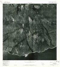
1977 Map of Makaopuhi Crater
USGS Topo · Published 1981About this map
Volcanic activity and the stark relief of the East Rift Zone define this orthophotograph, which captures the shifting terrain of the Big Island in the late 1970s. The landscape is dominated by massive pit craters, most notably the sprawling Makaopuhi Crater and the nearby Pauahi Crater. Unlike traditional line-drawn maps, this aerial imagery shows the exact reach and texture of various lava flows as they spill toward the Pacific Ocean coastline. This perspective is vital for geologists and local historians tracking the physical evolution of the island's southern shore, where points such as Apua Point and Kahue Point mark the interface between hardened volcanic rock and the sea. The image provides a high-fidelity record of the ground surface just years before significant new eruptions would further alter these same coordinates.
Find a feature on this map
5 named features on this map. Tap any name to fly to it.
Don’t see what you’re looking for? This feature index may not catch every label — zoom into the map to look around manually.
Map Details
Editions of this 1977 Makaopuhi Crater Map
This is the sole edition of this map. No revisions or reprints were ever made.
Other maps of this area

1921 · Kilauea
USGS Topo · 1:62,500

1922 · Puna
USGS Topo · 1:62,500

1923 · Pahala
USGS Topo · 1:62,500

1924 · Kilauea
USGS Topo · 1:62,500

1924 · Puna
USGS Topo · 1:62,500

1954 · Hawaii South
USGS Topo · 1:250,000

1959 · Hawaii South
USGS Topo · 1:250,000

1961 · Hawaii South
USGS Topo · 1:250,000

1962 · Hawaii South
USGS Topo · 1:250,000
1963 · Volcano
USGS Topo · 1:24,000