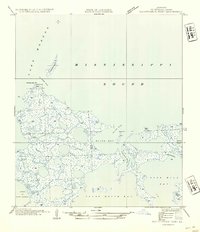
1954 Map of Malheureux Point
USGS Topo · Published 1954About this map
Malheureux Pt anchors this coastal survey of the St. Bernard Parish marshlands, where the waters of Lake Borgne and the Mississippi Sound meet. Compiled from 1935 field examinations and aerial photography, the map reveals a fragile landscape of fragmented landmasses like Le Petit Pass Id and Raccoon Id. The intricate network of tidal waterways is defined by Blind Pass and Le Petit Pass, which carve through the salt marsh to connect larger open waters such as Blind Bay and Nine Mile Bay. This mid-century study captures the labyrinthine drainage system of the outer delta, including the Lakes of Bayou Marron and the winding course of False Mouth Bayou. The level of detail in the shoreline at Three Mile Bay reflects a period before significant coastal erosion altered these specific marsh boundaries.
Find a feature on this map
16 named features on this map. Tap any name to fly to it.
Don’t see what you’re looking for? This feature index may not catch every label — zoom into the map to look around manually.
Map Details
Editions of this 1954 Malheureux Point Map
This is the sole edition of this map. No revisions or reprints were ever made.
Other maps of this area

1893 · Rigolets
USGS Topo · 1:62,500

1893 · Shell Beach
USGS Topo · 1:62,500

1893 · Toulme
USGS Topo · 1:62,500

1895 · Bodreau
USGS Topo · 1:62,500

1935 · English Lookout
USGS Topo · 1:31,680

1935 · Grand Island Pass
USGS Topo · 1:31,680

1936 · Rigolets
USGS Topo · 1:62,500

1939 · Shell Beach
USGS Topo · 1:62,500

1941 · Shell Beach
USGS Topo · 1:62,500

1946 · Oak Mound Bayou
USGS Topo · 1:31,680