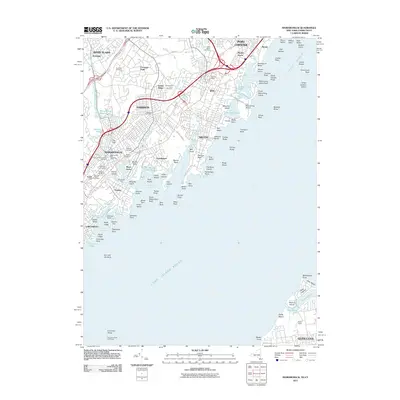
2011 Map of Mamaroneck
USGS Topo · Published 2011About this map
Long Island Sound dominates the southern landscape of this coastal New York survey, where the jagged shoreline is defined by numerous inlets and small islands. Dense residential developments across Harrison, Rye, and Mamaroneck reflect the suburban character of the early 21st century. Significant local history is preserved in a series of burial grounds like Greenwood Union Cemetery and the Old Mamaroneck Cemetery, providing touchpoints for genealogical research. The maritime environment is characterized by distinctive features such as the Execution Rocks Lighthouse and the intricate coves of Milton Harbor and Larchmont Harbor. Further inland, the infrastructure of the Hutchinson River Pkwy and the Mamaroneck River corridor illustrates the area's transport and drainage patterns. The map also captures the recreational and estate heritage of the Sound Shore, including Oakland Beach and the Pratts Estate.
Find a feature on this map
128 named features on this map. Tap any name to fly to it.
Don’t see what you’re looking for? This feature index may not catch every label — zoom into the map to look around manually.
Map Details
Editions of this 2011 Mamaroneck Map
This is the sole edition of this map. No revisions or reprints were ever made.
Other maps of this area

1891 · Harlem
USGS Topo · 1:62,500

1892 · Stamford
USGS Topo · 1:62,500

1892 · Tarrytown
USGS Topo · 1:62,500

1893 · Stamford
USGS Topo · 1:62,500

1893 · Tarrytown
USGS Topo · 1:62,500

1897 · Harlem
USGS Topo · 1:62,500

1897 · Oyster Bay
USGS Topo · 1:62,500

1898 · Harlem
USGS Topo · 1:62,500

1898 · Oyster Bay
USGS Topo · 1:62,500

1899 · Stamford
USGS Topo · 1:62,500