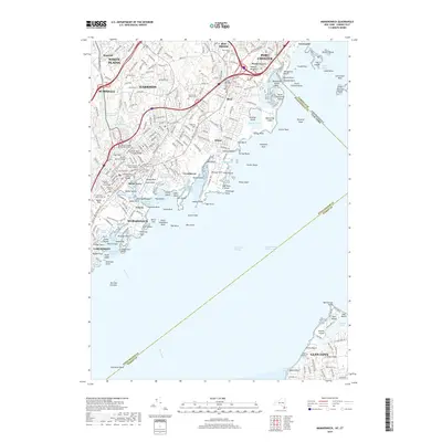
2019 Map of Mamaroneck
USGS Topo · Published 2019About this map
Mamaroneck and the surrounding coastline of the Long Island Sound are defined by a complex network of inlets, harbors, and islands. This area, spanning the border from White Plains down to Glen Cove, shows a densely developed suburban landscape characterized by legacy estates and local history preserved in its many small burial grounds. Genealogists will find notable sites such as the Eleazor Gedney Burial Ground, Solomon Gedney Burial Ground, and the Florence Powell Cem. The maritime character is prominent throughout, from the recreational waters of Playland Lake in Rye to the landmark Execution Rocks further out in the sound. The transportation spine of the region is clearly marked by the Metro-North corridor, which connects established communities like Harrison, Larchmont, and Port Chester, while the coastal geography is detailed through features like Milton Harbor and Delancey Point.
Find a feature on this map
124 named features on this map. Tap any name to fly to it.
Don’t see what you’re looking for? This feature index may not catch every label — zoom into the map to look around manually.
Map Details
Editions of this 2019 Mamaroneck Map
This is the sole edition of this map. No revisions or reprints were ever made.
Other maps of this area

1891 · Harlem
USGS Topo · 1:62,500

1892 · Stamford
USGS Topo · 1:62,500

1892 · Tarrytown
USGS Topo · 1:62,500

1893 · Stamford
USGS Topo · 1:62,500

1893 · Tarrytown
USGS Topo · 1:62,500

1897 · Harlem
USGS Topo · 1:62,500

1897 · Oyster Bay
USGS Topo · 1:62,500

1898 · Harlem
USGS Topo · 1:62,500

1898 · Oyster Bay
USGS Topo · 1:62,500

1899 · Stamford
USGS Topo · 1:62,500