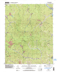
1996 Map of Man
USGS Topo · Published 2003About this map
The Guyandotte River cuts through the northeast corner of this Logan County terrain, where the settlement of Man serves as a local hub. Heavily influenced by the regional coal economy of the mid-to-late 20th century, the landscape is marked by numerous Mines, Tipples, and Strip Mines that dot the ridges and hollows. Transport corridors follow the narrow valleys, including the Island Creek RR and a network of unimproved roads like the Tramway near Crystal Block. Cultural landmarks are scattered throughout the winding drainages, such as Logan Douglas Sch at Superior Bottom and the Hatfield Ch near Hampden. The boundary between Logan and Mingo counties bisects the southern half of the sheet, crossing high points like Horsepen Mtn and the site of the Mingo Lookout Tower.
Find a feature on this map
63 named features on this map. Tap any name to fly to it.
Don’t see what you’re looking for? This feature index may not catch every label — zoom into the map to look around manually.
Map Details
Editions of this 1996 Man Map
This is the sole edition of this map. No revisions or reprints were ever made.
Other maps of this area

1887 · Warfield
USGS Topo · 1:125,000

1891 · Oceana
USGS Topo · 1:125,000

1891 · Warfield
USGS Topo · 1:125,000

1893 · Oceana
USGS Topo · 1:125,000

1898 · Oceana
USGS Topo · 1:125,000

1909 · Matewan
USGS Topo · 1:48,000

1909 · Gilbert
USGS Topo · 1:48,000

1910 · Holden
USGS Topo · 1:48,000

1912 · Gilbert
USGS Topo · 1:62,500

1912 · Holden
USGS Topo · 1:62,500