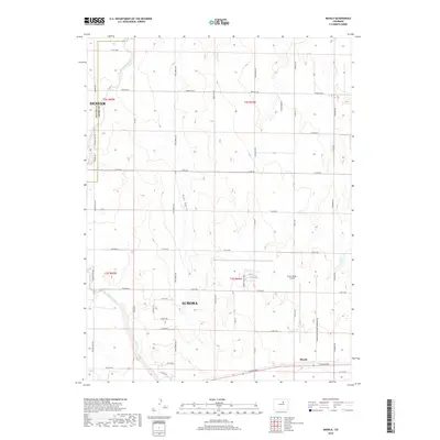
2019 Map of Manila
USGS Topo · Published 2019About this map
The high plains east of the Rocky Mountains take on a distinctly transitional character in this late 2010s survey, where the expanding boundaries of Denver and Aurora meet the traditional agricultural landscape. The namesake settlement of Manila sits at the southern edge of the quadrangle, positioned near the intersection of the regional road network. Dominating the central-eastern portion of the map is the Front Range Airport, a major aviation hub surrounded by a perimeter of modern infrastructure, including the Front Range Pkwy and the Front Range Airport Perimeter Rd. Despite this modernization, the land is still defined by its natural drainage patterns, with Box Elder Creek, Bear Gulch, and Horse Cr cutting through the terrain. The map details a rigid section-line grid of rural roads like Manilla Rd and Irondale Rd, illustrating the intersection of suburban growth and the legacy of Colorado's open ranch land.
Find a feature on this map
46 named features on this map. Tap any name to fly to it.
Don’t see what you’re looking for? This feature index may not catch every label — zoom into the map to look around manually.
Map Details
Editions of this 2019 Manila Map
This is the sole edition of this map. No revisions or reprints were ever made.
Other maps of this area

1890 · East Denver
USGS Topo · 1:125,000

1939 · Coal Creek
USGS Topo · 1:24,000

1942 · Mile High Lakes
USGS Topo · 1:31,680

1942 · Box Elder School
USGS Topo · 1:31,680

1942 · Coal Creek
USGS Topo · 1:31,680

1949 · Sunnydale
USGS Topo · 1:24,000

1949 · Bennett
USGS Topo · 1:24,000

1951 · Manila
USGS Topo · 1:24,000
1952 · Horse Creek
USGS Topo · 1:24,000

1953 · Denver
USGS Topo · 1:250,000