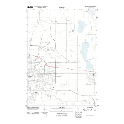
2010 Map of Mankato East
USGS Topo · Published 2010About this map
Mankato and its eastern suburbs are captured here at the beginning of the 2010s, showing a landscape where academic expansion, aviation, and historic burial grounds converge. The sprawling campus of Minnesota State University - Mankato dominates the southern part of the city near University Park of Mankato, while the Mankato Municipal Airport and its runways mark the plateau to the north. To the east, the community of Eagle Lake sits between its namesake water body and Eagle Lake Regency. A deep sense of local history is preserved in the cluster of burial sites overlooking the river valley, including Old Masonic Cemetery, Good Counsel Cemetery, and Calvary Cemetery. The northern reaches of the map transition into more rural territory, where the Wildlife Safari Museum and Bochland Cemetery are situated among the rectilinear grid of farm roads and scattered water bodies like Wita Lake.
Find a feature on this map
63 named features on this map. Tap any name to fly to it.
Don’t see what you’re looking for? This feature index may not catch every label — zoom into the map to look around manually.
Map Details
Editions of this 2010 Mankato East Map
This is the sole edition of this map. No revisions or reprints were ever made.
Other maps of this area

1950 · Mankato East
USGS Topo · 1:62,500

1951 · Mankato East
USGS Topo · 1:62,500

1951 · Mankato West
USGS Topo · 1:62,500

1953 · Saint Paul
USGS Topo · 1:250,000

1953 · New Ulm
USGS Topo · 1:250,000

1957 · New Ulm
USGS Topo · 1:250,000

1958 · New Ulm
USGS Topo · 1:250,000

1959 · Saint Paul
USGS Topo · 1:250,000

1965 · Cleveland
USGS Topo · 1:24,000

1965 · North Star
USGS Topo · 1:24,000