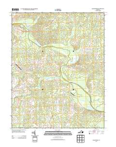
2013 Map of Mannboro
USGS Topo · Published 2013About this map
The Appomattox River winds through this rural landscape in Amelia County, defining much of the drainage and historical transport patterns of the region. Small settlements like Mannboro and Wilsons Corner anchor the road network, which includes the notable Patrick Henry Hwy and Hull Street Rd. The map records several river crossings with evocative names, most notably the Bevils-Devils Bridge Bridge and Goodes Bridge, reflecting centuries of local movement across the water.
Find a feature on this map
45 named features on this map. Tap any name to fly to it.
Don’t see what you’re looking for? This feature index may not catch every label — zoom into the map to look around manually.
Map Details
Editions of this 2013 Mannboro Map
This is the sole edition of this map. No revisions or reprints were ever made.
Other maps of this area

1897 · Amelia
USGS Topo · 1:125,000

1943 · Amelia
USGS Topo · 1:31,680

1943 · Goodes Bridge
USGS Topo · 1:31,680

1943 · Hallsboro
USGS Topo · 1:31,680

1943 · Clayville
USGS Topo · 1:24,000

1943 · Church Road
USGS Topo · 1:24,000

1943 · Winterpock
USGS Topo · 1:24,000
1943 · Chula
USGS Topo · 1:24,000

1943 · Richmond
USGS Topo · 1:250,000

1944 · Chula
USGS Topo · 1:31,680