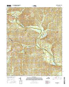
2016 Map of Mannboro
USGS Topo · Published 2016About this map
The Appomattox River winds through the borderlands of Chesterfield and Amelia counties, serving as a primary geographic anchor for this rural landscape. Near the river crossing at Goodes Bridge, the terrain is marked by a network of drainage systems including Goode Cr and Smacks Cr. To the south, the settlement of Mannboro stands near the headwaters of Long Br, connected to the surrounding countryside by historical routes such as Richmond Rd and Namozine Rd.
Find a feature on this map
43 named features on this map. Tap any name to fly to it.
Don’t see what you’re looking for? This feature index may not catch every label — zoom into the map to look around manually.
Map Details
Editions of this 2016 Mannboro Map
This is the sole edition of this map. No revisions or reprints were ever made.
Other maps of this area

1897 · Amelia
USGS Topo · 1:125,000

1943 · Amelia
USGS Topo · 1:31,680

1943 · Goodes Bridge
USGS Topo · 1:31,680

1943 · Hallsboro
USGS Topo · 1:31,680

1943 · Clayville
USGS Topo · 1:24,000

1943 · Church Road
USGS Topo · 1:24,000

1943 · Winterpock
USGS Topo · 1:24,000
1943 · Chula
USGS Topo · 1:24,000

1943 · Richmond
USGS Topo · 1:250,000

1944 · Chula
USGS Topo · 1:31,680