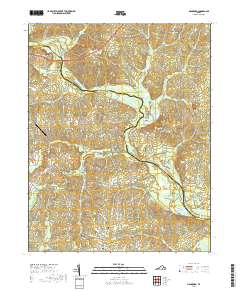
2019 Map of Mannboro
USGS Topo · Published 2019About this map
The Appomattox River winds through this Central Virginia landscape, defining the jagged border between Chesterfield and Amelia counties. The area is characterized by a dense network of creek drainages including Beaverpond Cr, Deep Creek, and Sappony Cr, which historically dictated the placement of early crossings like Goodes Bridge and Devils Bridge. The rural character of the region is anchored by the settlement of Mannboro in the south, connected to the surrounding countryside by historic thoroughfares such as Hull Street Rd and Namozine Rd. Local heritage is preserved at sites like Sappony Cem and Oak Grove Cem, while the Merlin Aerodrome signifies more modern land use near the Stonewall Dr corridor. The map reveals how the undulating terrain of the Piedmont continues to influence transit and settlement patterns centuries after the initial colonial expansion into these river valleys.
Find a feature on this map
43 named features on this map. Tap any name to fly to it.
Don’t see what you’re looking for? This feature index may not catch every label — zoom into the map to look around manually.
Map Details
Editions of this 2019 Mannboro Map
This is the sole edition of this map. No revisions or reprints were ever made.
Other maps of this area

1897 · Amelia
USGS Topo · 1:125,000

1943 · Amelia
USGS Topo · 1:31,680

1943 · Goodes Bridge
USGS Topo · 1:31,680

1943 · Hallsboro
USGS Topo · 1:31,680

1943 · Clayville
USGS Topo · 1:24,000

1943 · Church Road
USGS Topo · 1:24,000

1943 · Winterpock
USGS Topo · 1:24,000
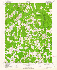
1943 · Chula
USGS Topo · 1:24,000

1943 · Richmond
USGS Topo · 1:250,000

1944 · Chula
USGS Topo · 1:31,680