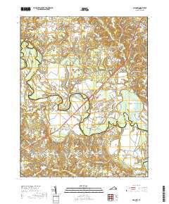
2019 Map of Manquin
USGS Topo · Published 2019About this map
The Pamunkey River winds through the heart of this landscape, forming the historical boundary between Hanover and King William counties. The river's serpentine course is marked by distinctive features such as the Island, the Meadows, and the sharp bend at the Horseshoe. Settlement patterns follow the higher ground above the expansive wetlands of Whiting Swamp and Judy Swamp, with hubs at Old Church, Manquin, and Central Garage. Local history is anchored by long-standing landmarks including McKendree Methodist Church Cem and Sharon Baptist Church Cem, which serve as vital points for genealogical research. The transition from traditional water-powered sites like Dabneys Millpond to modern infrastructure is evidenced by the prominent Pamunkey River Bridge carrying the Mechanicsville Tpke across the valley.
Find a feature on this map
100 named features on this map. Tap any name to fly to it.
Don’t see what you’re looking for? This feature index may not catch every label — zoom into the map to look around manually.
Map Details
Editions of this 2019 Manquin Map
This is the sole edition of this map. No revisions or reprints were ever made.
Other maps of this area

1894 · Richmond
USGS Topo · 1:62,500

1895 · Richmond
USGS Topo · 1:62,500

1918 · Doswell
USGS Topo · 1:62,500

1918 · Aylett
USGS Topo · 1:62,500

1920 · King William
USGS Topo · 1:62,500

1933 · Aylett
USGS Topo · 1:62,500

1934 · Seven Pines
USGS Topo · 1:24,000

1938 · Seven Pines
USGS Topo · 1:31,680

1938 · Studley
USGS Topo · 1:31,680

1943 · Richmond
USGS Topo · 1:250,000