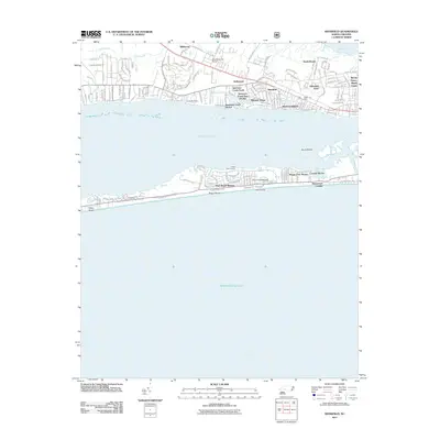
2011 Map of Mansfield
USGS Topo · Published 2011About this map
Bogue Banks and the surrounding coastal waters define this maritime landscape in Carteret County. The barrier island is heavily developed with communities like Pine Knoll Shores and Indian Beach, while the mainland side is characterized by residential clusters such as Mansfield and Wildwood. The map captures the infrastructure of the Crystal Coast just after the first decade of the 21st century, showing how Bogue Sound separates the residential developments of Mitchell Village and Bonham Heights from the oceanfront. Nautical life is prominent, evidenced by Spooners Creek Harbor and landmarks such as Hoop Pole Landing and Willis Landing. Aviation and military history are also present on the mainland through Morehead City Airport and Camp Morehead, illustrating the area's role as a regional transportation and activities hub along the Newport River.
Find a feature on this map
146 named features on this map. Tap any name to fly to it.
Don’t see what you’re looking for? This feature index may not catch every label — zoom into the map to look around manually.
Map Details
Editions of this 2011 Mansfield Map
This is the sole edition of this map. No revisions or reprints were ever made.
Other maps of this area

1949 · Beaufort
USGS Topo · 1:24,000

1949 · Newport
USGS Topo · 1:24,000

1949 · Salter Path
USGS Topo · 1:24,000

1949 · Mansfield
USGS Topo · 1:24,000

1949 · Core Creek
USGS Topo · 1:24,000

1949 · Masontown
USGS Topo · 1:24,000

1951 · Salter Path
USGS Topo · 1:24,000

1951 · Newport
USGS Topo · 1:24,000

1951 · Core Creek
USGS Topo · 1:24,000
1951 · Peltier Creek
USGS Topo · 1:24,000