1949 Map of Newport
USGS Topo · Published 1983About this map
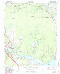
Newport sits at the head of the Newport River tidal basin, serving as a focal point for this coastal landscape where timber, swamp, and rail intersect. The town is anchored by the Atlantic and North Carolina Railroad, which cuts southwest toward the coast. Surrounding the settlement, the geography is defined by a dense network of water bodies, including Little Deep Cr and School House Branch, which drain into the river. To the north, the terrain transitions into the heavily wooded expanse of the Croatan National Forest and Croatan Game Land.
Find a feature on this map
43 named features on this map. Tap any name to fly to it.
Don’t see what you’re looking for? This feature index may not catch every label — zoom into the map to look around manually.
Map Details
Editions of this 1949 Newport Map
This is the sole edition of this map. No revisions or reprints were ever made.
Other maps of this area
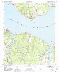
1949 · Havelock
USGS Topo · 1:24,000
1949 · Beaufort
USGS Topo · 1:24,000
1949 · Merrimon
USGS Topo · 1:24,000

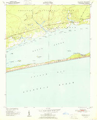
1949 · Salter Path
USGS Topo · 1:24,000

1949 · Mansfield
USGS Topo · 1:24,000
1949 · Cherry Point
USGS Topo · 1:24,000

1949 · Core Creek
USGS Topo · 1:24,000

1949 · Masontown
USGS Topo · 1:24,000
1951 · Salter Path
USGS Topo · 1:24,000
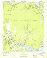
1951 · Newport
USGS Topo · 1:24,000