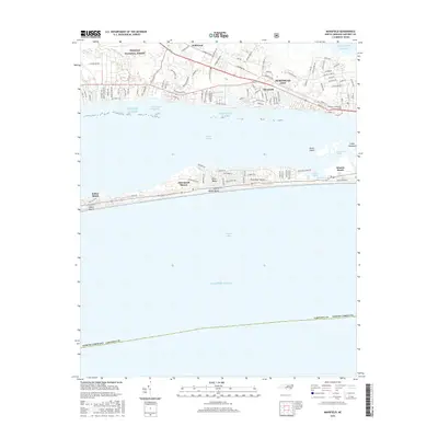
2016 Map of Mansfield
USGS Topo · Published 2016About this map
Bogue Sound serves as the central geographic divide in this coastal survey, separating the mainland settlements of Morehead City and Mansfield from the barrier island developments on Bogue Banks. The map captures the dense residential networks of Pine Knoll Shores and Atlantic Beach, contrasted with the protected marshlands and maritime forests of the Croatan National Forest to the northwest. On the mainland, Wildwood sits near the edge of Hull Swamp, while the southern shore of the city is defined by Spooner Cr and the campus of Carteret Community Coll. The engineering of the Intracoastal Waterway is clearly visible as it passes through the sound, illustrating the region's reliance on maritime navigation and its evolution into a major coastal destination by the early 21st century.
Find a feature on this map
115 named features on this map. Tap any name to fly to it.
Don’t see what you’re looking for? This feature index may not catch every label — zoom into the map to look around manually.
Map Details
Editions of this 2016 Mansfield Map
This is the sole edition of this map. No revisions or reprints were ever made.
Other maps of this area

1949 · Beaufort
USGS Topo · 1:24,000

1949 · Newport
USGS Topo · 1:24,000

1949 · Salter Path
USGS Topo · 1:24,000

1949 · Mansfield
USGS Topo · 1:24,000

1949 · Core Creek
USGS Topo · 1:24,000

1949 · Masontown
USGS Topo · 1:24,000

1951 · Salter Path
USGS Topo · 1:24,000

1951 · Newport
USGS Topo · 1:24,000

1951 · Core Creek
USGS Topo · 1:24,000
1951 · Peltier Creek
USGS Topo · 1:24,000