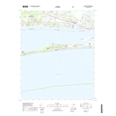
2019 Map of Mansfield
USGS Topo · Published 2019About this map
Bogue Sound separates the mainland of Morehead City from the thin barrier island of Bogue Banks, illustrating the complex coastal geography of the North Carolina coast. On the mainland, the landscape transitions from the protected timberlands of the Croatan National Forest and the headwaters of Hull Swamp into developed residential corridors near Wildwood and the community of Mansfield. The Intracoastal Waterway serves as the primary maritime artery, threading through the sounds behind the barrier beach. Along the oceanfront, the map details the distinct resort and residential footprints of Indian Beach, Pine Knoll Shores, and Atlantic Beach. These settlements are shaped by the shifting sands of the banks, where features like Drum Shoals and Cheesemans Inlet mark the meeting of inland waters and the Atlantic Ocean.
Find a feature on this map
121 named features on this map. Tap any name to fly to it.
Don’t see what you’re looking for? This feature index may not catch every label — zoom into the map to look around manually.
Map Details
Editions of this 2019 Mansfield Map
This is the sole edition of this map. No revisions or reprints were ever made.
Other maps of this area

1949 · Beaufort
USGS Topo · 1:24,000

1949 · Newport
USGS Topo · 1:24,000

1949 · Salter Path
USGS Topo · 1:24,000

1949 · Mansfield
USGS Topo · 1:24,000

1949 · Core Creek
USGS Topo · 1:24,000

1949 · Masontown
USGS Topo · 1:24,000

1951 · Salter Path
USGS Topo · 1:24,000

1951 · Newport
USGS Topo · 1:24,000

1951 · Core Creek
USGS Topo · 1:24,000
1951 · Peltier Creek
USGS Topo · 1:24,000