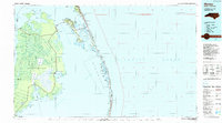
1985 Map of Manteo
USGS Topo · Published 1990About this map
Roanoke Island serves as the geographic and historic hub of this 1980s coastal survey, anchored by the town of Manteo and the fishing village of Wanchese. The map details the intricate relationship between the Inner Banks and the barrier islands, showing the maritime infrastructure of the Atlantic Ocean front, including the Oregon Inlet Lifeboat Station and a U.S. Coast Guard Station. Significant land preservation and history are evident at the Fort Raleigh National Historic Site and Jockey Ridge State Park.
Find a feature on this map
51 named features on this map. Tap any name to fly to it.
Don’t see what you’re looking for? This feature index may not catch every label — zoom into the map to look around manually.
Map Details
Editions of this 1985 Manteo Map
2 editions found

Other maps of this area

1940 · Kitty Hawk
USGS Topo · 1:62,500

1940 · Powells Point
USGS Topo · 1:62,500

1940 · Wade Point
USGS Topo · 1:62,500

1943 · Wade Point
USGS Topo · 1:62,500

1943 · Columbia
USGS Topo · 1:125,000

1943 · Roanoke Island
USGS Topo · 1:125,000

1946 · Eastville
USGS Topo · 1:250,000

1946 · Currituck Sound
USGS Topo · 1:250,000

1948 · Wade Point
USGS Topo · 1:62,500

1951 · Middletown Anchorage
USGS Topo · 1:24,000