
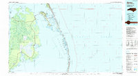
1985 Map of Manteo
USGS Topo · Published 1985About this map
The Outer Banks of North Carolina, as documented in the mid-1980s, reveal a landscape defined by the thin barrier between the Atlantic and several large sounds. On Roanoke Island, the Fort Raleigh National Historic Site and the landmark Mother Vineyard near Manteo sit at the cultural heart of the region. The map shows the sprawling Cape Hatteras National Seashore stretching south through Rodanthe and Salvo, encompassing the critical Pea Island National Wildlife Refuge.
Find a feature on this map
138 named features on this map. Tap any name to fly to it.
Don’t see what you’re looking for? This feature index may not catch every label — zoom into the map to look around manually.
Map Details
Editions of this 1985 Manteo Map
2 editions found
Other maps of this area

1940 · Kitty Hawk
USGS Topo · 1:62,500

1940 · Powells Point
USGS Topo · 1:62,500

1940 · Wade Point
USGS Topo · 1:62,500

1943 · Wade Point
USGS Topo · 1:62,500

1943 · Columbia
USGS Topo · 1:125,000

1943 · Roanoke Island
USGS Topo · 1:125,000

1946 · Eastville
USGS Topo · 1:250,000

1946 · Currituck Sound
USGS Topo · 1:250,000

1948 · Wade Point
USGS Topo · 1:62,500

1951 · Middletown Anchorage
USGS Topo · 1:24,000