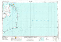
1957 Map of Manteo
USGS Topo · Published 1974About this map
Cape Hatteras National Seashore dominates this 1950s survey, capturing the Outer Banks before the era of intensive modern development. The mapping shows the delicate geography of Hatteras Island and Ocracoke Island, anchored by the iconic Cape Hatteras Lighthouse and the small coastal villages of Avon, Buxton, and Hatteras. Further north, Roanoke Island serves as a cultural hub, home to Manteo and the commemorative site of Fort Raleigh NHS. Across the Pamlico Sound, the mainland is characterized by the expansive Dare County Range Military Reservation and the remote settlement of Buffalo City near the Alligator River. The presence of numerous U S Coast Guard Stations and the Billy Mitchell Field underscores the region's strategic maritime and aviation significance during the mid-20th century.
Find a feature on this map
112 named features on this map. Tap any name to fly to it.
Don’t see what you’re looking for? This feature index may not catch every label — zoom into the map to look around manually.
Map Details
Editions of this 1957 Manteo Map
3 editions found

Other maps of this area

1940 · Kitty Hawk
USGS Topo · 1:62,500

1940 · Powells Point
USGS Topo · 1:62,500

1940 · Wade Point
USGS Topo · 1:62,500

1943 · Wade Point
USGS Topo · 1:62,500

1943 · Columbia
USGS Topo · 1:125,000

1943 · Roanoke Island
USGS Topo · 1:125,000

1946 · Eastville
USGS Topo · 1:250,000

1946 · Currituck Sound
USGS Topo · 1:250,000

1948 · Wade Point
USGS Topo · 1:62,500

1948 · Cape Hatteras
USGS Topo · 1:24,000