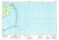
1957 Map of Manteo
USGS Topo · Published 1974About this map
The barrier islands of the Outer Banks stretch across this mid-century survey, defining the boundary between the Atlantic Ocean and the expansive waters of Pamlico Sound and Albemarle Sound. The map focuses on the delicate landscape of Bodie Island, Hatteras Island, and Ocracoke Island, where conservation efforts are evident through the Cape Hatteras National Seashore and Pea Island National Wildlife Refuge. Historical and maritime landmarks punctuate the coast, from the Cape Hatteras Lighthouse near Cape Hatteras to the Fort Raleigh NHS on Roanoke Island.
Find a feature on this map
67 named features on this map. Tap any name to fly to it.
Don’t see what you’re looking for? This feature index may not catch every label — zoom into the map to look around manually.
Map Details
Editions of this 1957 Manteo Map
3 editions found

Other maps of this area

1940 · Kitty Hawk
USGS Topo · 1:62,500

1940 · Powells Point
USGS Topo · 1:62,500

1940 · Wade Point
USGS Topo · 1:62,500

1943 · Wade Point
USGS Topo · 1:62,500

1943 · Columbia
USGS Topo · 1:125,000

1943 · Roanoke Island
USGS Topo · 1:125,000

1946 · Eastville
USGS Topo · 1:250,000

1946 · Currituck Sound
USGS Topo · 1:250,000

1948 · Wade Point
USGS Topo · 1:62,500

1948 · Cape Hatteras
USGS Topo · 1:24,000