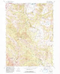
1991 Map of Mantua
USGS Topo · Published 1992About this map
Mantua Reservoir serves as a central landmark for this high-elevation area, where the settlement of Mantua sits at the junction of Box Elder Creek and Maple Creek. The landscape transitions from the developed flats of Dock Flat and Clay Valley into the steep terrain of the Cache National Forest, punctuated by prominent peaks like Willard Peak and Black Mountain. Human impact on these peaks is evident through a series of resource extraction sites, including the Silver Eagle Mine, American Mine, and Eldorado Mine. Regional social history is represented by the Bel Mid Girls Home and recreation sites such as Camp Utaba and Camp Lamoille. The intricate mapping of aqueduct and pipeline infrastructure near Brigham City reveals the complex water management systems required to sustain these mountain-valley communities.
Find a feature on this map
66 named features on this map. Tap any name to fly to it.
Don’t see what you’re looking for? This feature index may not catch every label — zoom into the map to look around manually.
Map Details
Editions of this 1991 Mantua Map
2 editions found
Other maps of this area

1914 · Logan
USGS Topo · 1:125,000

1916 · Logan
USGS Topo · 1:125,000

1954 · Ogden
USGS Topo · 1:250,000

1954 · Brigham City
USGS Topo · 1:250,000

1955 · Plain City
USGS Topo · 1:24,000

1955 · Paradise
USGS Topo · 1:24,000

1955 · Mantua
USGS Topo · 1:24,000

1955 · Huntsville
USGS Topo · 1:24,000

1955 · James Peak
USGS Topo · 1:24,000

1955 · Willard
USGS Topo · 1:24,000