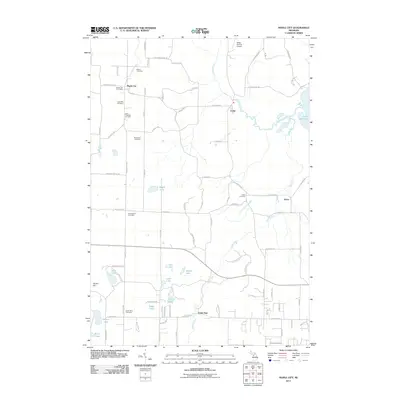
2011 Map of Maple City
USGS Topo · Published 2011About this map
Maple City and the surrounding township of Solon are defined by a network of glacial lakes and small agricultural settlements. In this 2011 edition, the community centers of Cedar and Solon remain connected by the meandering course of Victoria Creek and the southern reaches of Lake Leelanau. For genealogists, the landscape is densely populated with early burial grounds, including the Nash-Pettengill Cemetery, Saint Rita Cemetery, and the Kasson Cemetery.
Find a feature on this map
90 named features on this map. Tap any name to fly to it.
Don’t see what you’re looking for? This feature index may not catch every label — zoom into the map to look around manually.
Map Details
Editions of this 2011 Maple City Map
This is the sole edition of this map. No revisions or reprints were ever made.
Other maps of this area

1954 · Traverse City
USGS Topo · 1:250,000

1956 · Kingsley
USGS Topo · 1:62,500

1956 · Thompsonville
USGS Topo · 1:62,500

1957 · Traverse City
USGS Topo · 1:62,500

1957 · Maple City
USGS Topo · 1:62,500

1958 · Traverse City
USGS Topo · 1:250,000

1976 · Thompsonville NE
USGS Topo · 1:24,000

1976 · Thompsonville NW
USGS Topo · 1:24,000
1983 · Burdickville
USGS Topo · 1:24,000

1983 · Maple City
USGS Topo · 1:24,000