
1972 Map of Maple Falls
USGS Topo · Published 1976About this map
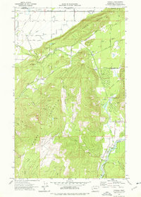
Maple Falls sits at the base of several prominent peaks in this 1970s topographic study. The landscape is defined by the steep slopes of Red Mountain, Black Mountain, and Slide Mountain, which hem in the drainage basins of Maple Creek and Doaks Creek. To the north, the Columbia Valley stretches toward the international boundary, marked by the line between the United States and Canada.
Find a feature on this map
32 named features on this map. Tap any name to fly to it.
Don’t see what you’re looking for? This feature index may not catch every label — zoom into the map to look around manually.
Map Details
Editions of this 1972 Maple Falls Map
This is the sole edition of this map. No revisions or reprints were ever made.
Other maps of this area

1909 · Mt Baker
USGS Topo · 1:192,000

1915 · Mt. Baker
USGS Topo · 1:250,000

1919 · Van Zandt
USGS Topo · 1:62,500

1951 · Van Zandt
USGS Topo · 1:62,500

1952 · Mt. Baker
USGS Topo · 1:62,500

1955 · Concrete
USGS Topo · 1:250,000

1957 · Victoria
USGS Topo · 1:250,000

1958 · Concrete
USGS Topo · 1:250,000

1962 · Concrete
USGS Topo · 1:250,000
1972 · Kendall
USGS Topo · 1:24,000