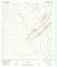
1983 Map of Maravillas Gap
USGS Topo · Published 1984About this map
Maravillas Gap serves as a distinct break in the high ground of Brewster County, providing a natural passage between the elevated ridges and the broad expanse of the Santiago Flats. This desert landscape in the early 1980s was defined by its water sources and sparse infrastructure, where Maravillas Creek and its tributaries, including Reynolds Creek and Hackberry Creek, dictated the movement of people and livestock. Evidence of land use is found in the scattered Tank sites, a Well, and a Drill Hole near Three Mile Hill. The reliance on unpaved transportation is clear, with a Jeep Trail and a Landing Strip providing the only modern connections to this remote reach of West Texas. A permanent Spring in the southeast corner further highlights the critical nature of water in this arid environment.
Find a feature on this map
12 named features on this map. Tap any name to fly to it.
Don’t see what you’re looking for? This feature index may not catch every label — zoom into the map to look around manually.
Map Details
Editions of this 1983 Maravillas Gap Map
This is the sole edition of this map. No revisions or reprints were ever made.
Other maps of this area

1917 · Santiago Peak
USGS Topo · 1:62,500

1917 · Hood Spring
USGS Topo · 1:62,500

1918 · Bone Spring
USGS Topo · 1:125,000

1918 · Hood Spring
USGS Topo · 1:62,500

1918 · Santiago Peak
USGS Topo · 1:62,500

1920 · Monument Spring
USGS Topo · 1:62,500

1920 · Marathon
USGS Topo · 1:62,500

1921 · Monument Spring
USGS Topo · 1:62,500

1921 · Marathon
USGS Topo · 1:62,500

1931 · Hood Spring
USGS Topo · 1:62,500