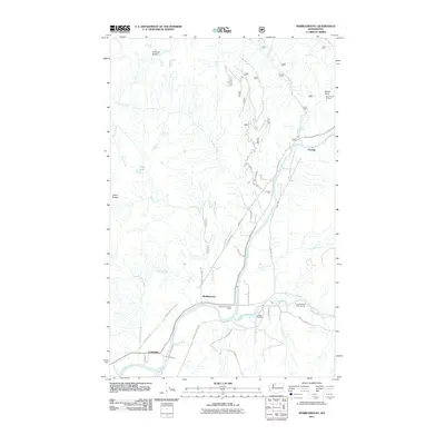
2011 Map of Marblemount
USGS Topo · Published 2011About this map
The confluence of the Skagit River and Cascade River anchors the settlement of Marblemount, a community characterized by its strategic position at the edge of the Washington wilderness. In this 2011 survey, the township serves as a central hub for the surrounding valley, supported by the Marblemount Post Office and the nearby Skagit Hatchery. The landscape transition from riverbank to high peak is sharp, with the Diobsud Buttes and Bacon Point rising above the drainage basins of Bacon Creek and Diobsud Creek. Small residential nodes such as Portage and Corkindale dot the arterial roads, while the Bacon Point Lookout suggests the area's ongoing importance for forest management. To the south, recreational and local access is maintained through sites like the Cascade Island Campground and numerous designated forest roads including Rockport Cascade Rd and South Cascade Rd, reflecting a modern era where timber heritage and conservation coexist.
Find a feature on this map
38 named features on this map. Tap any name to fly to it.
Don’t see what you’re looking for? This feature index may not catch every label — zoom into the map to look around manually.
Map Details
Editions of this 2011 Marblemount Map
This is the sole edition of this map. No revisions or reprints were ever made.
Other maps of this area

1899 · Glacier Peak
USGS Topo · 1:125,000

1899 · Stillaguamish
USGS Topo · 1:125,000

1901 · Glacier Peak
USGS Topo · 1:125,000

1901 · Stilaguamish
USGS Topo · 1:125,000

1909 · Mt Baker
USGS Topo · 1:192,000

1915 · Mt. Baker
USGS Topo · 1:250,000

1952 · Lake Shannon
USGS Topo · 1:62,500

1953 · Marblemount
USGS Topo · 1:62,500

1955 · Concrete
USGS Topo · 1:250,000

1958 · Concrete
USGS Topo · 1:250,000