1995 Map of Marcus Hook
USGS Topo · Published 2000About this map
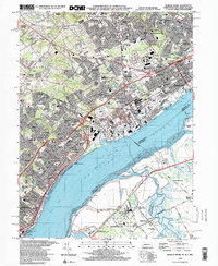
Industrial developments and established residential suburbs line the northern bank of the Delaware River in this mid-1990s survey. The landscape is dominated by the complex infrastructure of the Conrail lines and extensive industrial facilities, including various Tank Farms and Industrial Waste Ponds that flank the river's edge. This heavy industry is juxtaposed against long-standing community landmarks such as Neumann College and the St Francis Monastery, illustrating the densely packed multi-use nature of the tri-state border region.
Find a feature on this map
111 named features on this map. Tap any name to fly to it.
Don’t see what you’re looking for? This feature index may not catch every label — zoom into the map to look around manually.
Map Details
Editions of this 1995 Marcus Hook Map
This is the sole edition of this map. No revisions or reprints were ever made.
Other maps of this area

1890 · Salem
USGS Topo · 1:62,500

1894 · Chester
USGS Topo · 1:62,500

1896 · Chester
USGS Topo · 1:62,500

1898 · Salem
USGS Topo · 1:62,500

1898 · Chester
USGS Topo · 1:62,500

1901 · Camden
USGS Topo · 1:125,000

1901 · West Chester
USGS Topo · 1:62,500

1904 · West Chester
USGS Topo · 1:62,500

1904 · Wilmington
USGS Topo · 1:62,500

1906 · Wilmington
USGS Topo · 1:62,500