
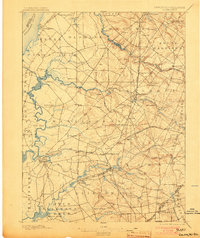
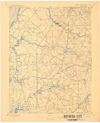
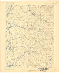
1898 Map of Salem
USGS Topo · Published 1898About this map
Salem Canal cuts through the marshy lowland of Lower Penns Neck in this late 19th-century survey of southwestern New Jersey. The landscape is defined by the winding tributaries of the Delaware River, including the meandering Mannington Creek and Alloway Creek, which serve as the primary drainage for a region transitioning from tidal flats to rolling farmland. A dense network of small villages and milling sites like Avis Mills and Sharptown reflects an economy deeply tied to water power and river transport.
Find a feature on this map
84 named features on this map. Tap any name to fly to it.
Don’t see what you’re looking for? This feature index may not catch every label — zoom into the map to look around manually.
Map Details
Editions of this 1898 Salem Map
4 editions found
Other maps of this area

1890 · Salem
USGS Topo · 1:62,500

1890 · Bay Side
USGS Topo · 1:62,500

1890 · Bridgeton
USGS Topo · 1:62,500

1890 · Glassboro
USGS Topo · 1:62,500

1891 · Philadelphia
USGS Topo · 1:62,500

1894 · Bay Side
USGS Topo · 1:62,500

1894 · Bridgeton
USGS Topo · 1:62,500

1894 · Chester
USGS Topo · 1:62,500

1894 · Philadelphia
USGS Topo · 1:62,500

1896 · Philadelphia
USGS Topo · 1:62,500