1890 Map of Salem
USGS Topo · Published 1895About this map
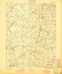
The Delaware River forms the western boundary of this coastal plain landscape, where tidal creeks like Mannington Creek and Alloway Creek wind through the lowlands of South Jersey. Surveyed in 1886, the map reveals a mature agricultural and milling economy centered on villages such as Woodstown and Sharptown. The industrial character of the era is defined by the dense network of rail lines, including the Delaware River R.R. and the West Jersey Railroad, which connected small stations like Perkintown Station and Alloway Station to broader markets.
Find a feature on this map
87 named features on this map. Tap any name to fly to it.
Don’t see what you’re looking for? This feature index may not catch every label — zoom into the map to look around manually.
Map Details
Editions of this 1890 Salem Map
2 editions found
Other maps of this area

1890 · Salem
USGS Topo · 1:62,500

1890 · Bay Side
USGS Topo · 1:62,500

1890 · Bridgeton
USGS Topo · 1:62,500

1890 · Glassboro
USGS Topo · 1:62,500

1891 · Philadelphia
USGS Topo · 1:62,500

1894 · Bay Side
USGS Topo · 1:62,500

1894 · Bridgeton
USGS Topo · 1:62,500

1894 · Chester
USGS Topo · 1:62,500

1894 · Philadelphia
USGS Topo · 1:62,500

1896 · Philadelphia
USGS Topo · 1:62,500