1995 Map of Salem
USGS Topo · Published 1999About this map
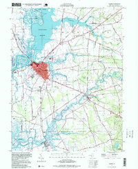
Salem sits at the heart of this landscape, where the Salem River meets a complex network of marshlands and tidal creeks. The settlement pattern reflects the area's deep coastal heritage, with centers like Quinton and Hancocks Bridge connected by historic corridors such as Quaker Neck Road. Evidence of the region’s early educational and social infrastructure is scattered throughout the rural townships, preserved in the locations of the Town Hall Sch, Wyncoop Sch, and Elsinboro Sch. Along the riverbanks, features like Majors Wharf and Sinnickson Landing underscore the maritime economy that once dominated these shores.
Find a feature on this map
68 named features on this map. Tap any name to fly to it.
Don’t see what you’re looking for? This feature index may not catch every label — zoom into the map to look around manually.
Map Details
Editions of this 1995 Salem Map
This is the sole edition of this map. No revisions or reprints were ever made.
Other maps of this area

1890 · Salem
USGS Topo · 1:62,500

1890 · Bay Side
USGS Topo · 1:62,500

1894 · Bay Side
USGS Topo · 1:62,500

1898 · Salem
USGS Topo · 1:62,500

1899 · Vineland
USGS Topo · 1:125,000

1899 · Dover
USGS Topo · 1:125,000

1901 · Camden
USGS Topo · 1:125,000

1904 · Wilmington
USGS Topo · 1:62,500

1906 · Dover
USGS Topo · 1:125,000

1906 · Wilmington
USGS Topo · 1:62,500
Featured Places
- Pennsville Township, NJ
- Salem, NJ
- Quinton Township, NJ
- Lower Alloways Creek Township, NJ
- Alloway Township, NJ