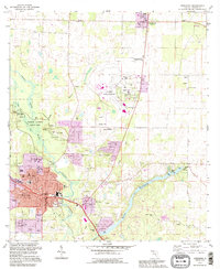
1994 Map of Marianna
USGS Topo · Published 1995About this map
The Chipola River carves a path through this section of Jackson County, anchoring a landscape where karst geography and local history meet. Just north of the county seat at Marianna, the Florida Caverns State Park reveals a complex subterranean world near Blue Hole Spring and the Muddy Branch tributary. This 1994 revision highlights the expansion of residential and educational hubs, such as the Dogwood Heights neighborhood and the Chipola Jr College campus, alongside long-standing rural institutions like Greenwood Chapel and Mount Tabor Ch. Numerous burial grounds including Orange Hill Cem, Riverside Cem, and the family-named Dyke Cem provide essential data for genealogists. The region's economy and infrastructure are evidenced by the Marianna Municipal Airport, the Florida Agriculture Research Center, and multiple sandpits, while the Boat Millpond and Merritts Millpond illustrate the historical management of the area's waterways.
Find a feature on this map
54 named features on this map. Tap any name to fly to it.
Don’t see what you’re looking for? This feature index may not catch every label — zoom into the map to look around manually.
Map Details
Editions of this 1994 Marianna Map
This is the sole edition of this map. No revisions or reprints were ever made.
Other maps of this area

1952 · Cypress
USGS Topo · 1:24,000

1952 · Oakdale
USGS Topo · 1:24,000

1952 · Kynesville
USGS Topo · 1:24,000

1952 · Dellwood
USGS Topo · 1:24,000

1952 · Cottondale East
USGS Topo · 1:24,000

1952 · Malone
USGS Topo · 1:24,000

1952 · Bascom
USGS Topo · 1:24,000

1952 · Sills
USGS Topo · 1:24,000

1952 · Marianna
USGS Topo · 1:24,000

1954 · Tallahassee
USGS Topo · 1:250,000