
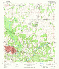
1952 Map of Marianna
USGS Topo · Published 1953About this map
Marianna serves as the focal point of this Jackson County survey, situated just south of the sprawling Florida Caverns State Park. The post-war landscape is defined by its institutional and educational footprints, including the Northwest Florida State Hospital and the early campus of Chipola Junior College. The Louisville and Nashville RR cuts through the city, anchoring the local economy to the rail network, while the Chipola River and Merritts Mill Pond dominate the hydrology of the area. Local genealogy and community life are well-documented through numerous rural landmarks such as St Mark Ch, Friendship Ch, and family-named burial grounds like Dyke Cem and Rouhac Cem. The presence of the Marianna Municipal Airport and the County Prison Camp further illustrate the mid-century development and land use patterns in this Florida Panhandle region.
Find a feature on this map
29 named features on this map. Tap any name to fly to it.
Don’t see what you’re looking for? This feature index may not catch every label — zoom into the map to look around manually.
Map Details
Editions of this 1952 Marianna Map
2 editions found
Other maps of this area

1952 · Cypress
USGS Topo · 1:24,000

1952 · Oakdale
USGS Topo · 1:24,000

1952 · Kynesville
USGS Topo · 1:24,000

1952 · Dellwood
USGS Topo · 1:24,000

1952 · Cottondale East
USGS Topo · 1:24,000

1952 · Malone
USGS Topo · 1:24,000

1952 · Bascom
USGS Topo · 1:24,000

1952 · Sills
USGS Topo · 1:24,000

1954 · Tallahassee
USGS Topo · 1:250,000

1959 · Tallahassee
USGS Topo · 1:250,000