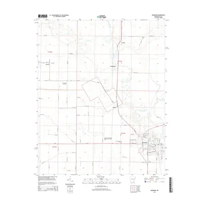
2014 Map of Marianna
USGS Topo · Published 2014About this map
The L'Anguille River meanders southward through this corner of the Arkansas Delta, creating a complex landscape of oxbows and sloughs including Three Mile Slough. The town of Marianna serves as the central hub, showing a structured grid of streets such as West Chestnut and South Alabama Streets. This 2014 survey documents a mix of agricultural aviation and traditional community infrastructure, with the Marianna/Lee County Airport-Steve Edwards Field and Frost Flying Inc Airport situated near smaller hamlets like Felton and Wrightland. Local genealogy is well-supported by several documented burial sites, including Mound City Cem, Andrews Cem, and Haynie Cem, which are scattered among the rural roads and creek drainages like Larkin Cr and Big Cypress Cr. The road network is particularly dense with Lee County routes, illustrating the connectivity between outlying settlements like Canaan and Westor and the river-bottom lands.
Find a feature on this map
85 named features on this map. Tap any name to fly to it.
Don’t see what you’re looking for? This feature index may not catch every label — zoom into the map to look around manually.
Map Details
Editions of this 2014 Marianna Map
This is the sole edition of this map. No revisions or reprints were ever made.
Other maps of this area

1939 · Park Place
USGS Topo · 1:62,500

1939 · Latour
USGS Topo · 1:62,500

1940 · Marvell
USGS Topo · 1:62,500

1940 · Marianna
USGS Topo · 1:62,500

1948 · Helena
USGS Topo · 1:250,000

1950 · Helena
USGS Topo · 1:250,000

1955 · Park Place
USGS Topo · 1:62,500

1955 · Latour
USGS Topo · 1:62,500

1955 · Helena
USGS Topo · 1:250,000

1956 · Marvell
USGS Topo · 1:62,500