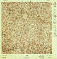
1947 Map of Maricao NE
USGS Topo · Published 1947About this map
Agricultural life in the interior of Puerto Rico in the 1940s is defined by the network of estates and coffee plantations that dot the landscape. At this time, family-named estates like Hacienda Lealtad and Hacienda Ballester are the primary centers of settlement, linked by winding roads through the complex terrain of Bucarabones and Chamorro. The map documents the intricate topographical details of the Cordillera Central, where the headwaters of the Rio Prieto and Rio Blanco carve deep into the mountainside. Spiritual life is centered at the Iglesia Miraflores, situated on a ridge between the municipal lines of Las Marias, Maricao, and Lares. This survey captures a specific era of rural land use before the transition toward more industrial economies, preserving the names of localized landmarks like Cerro de las Mulas and the subdivisions of Indiera Baja and Indiera Alta.
Find a feature on this map
21 named features on this map. Tap any name to fly to it.
Don’t see what you’re looking for? This feature index may not catch every label — zoom into the map to look around manually.
Map Details
Editions of this 1947 Maricao NE Map
This is the sole edition of this map. No revisions or reprints were ever made.
Other maps of this area

1938 · San Sebastian
USGS Topo · 1:20,000

1941 · San Sebastian
USGS Topo · 1:30,000

1946 · Maricao
USGS Topo · 1:30,000

1946 · Bayaney
USGS Topo · 1:30,000

1946 · Monte Guilarte
USGS Topo · 1:30,000
1947 · Maricao NO
USGS Topo · 1:10,000
1947 · Monte Guilarte SO
USGS Topo · 1:10,000
1947 · Maricao SO
USGS Topo · 1:10,000
1947 · Monte Guilarte NO
USGS Topo · 1:10,000
1947 · Maricao SE
USGS Topo · 1:10,000