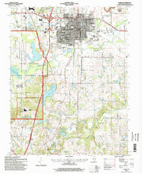
1996 Map of Marion
USGS Topo · Published 1998About this map
Marion serves as a major regional hub in Williamson County, defined by a dense grid of streets like Main Street and Carter Street and anchored by the county courthouse. The city's mid-century growth is evident in its numerous neighborhood schools, including McKinley Sch and Jefferson Sch, and large public institutions like the VA Hospital. To the south, the landscape transitions into the expansive Crab Orchard National Wildlife Refuge and the high-security grounds of the Federal Penitentiary. Outside the city limits, the rural character is preserved around the smaller settlements of Hudgens and Neilson, where country churches such as Shiloh Ch and Fountain Ch mark the crossroads. The area is also deeply tied to its natural resources and infrastructure, featuring the Marion Reservoir and a network of railroads including the Illinois Central Railroad and Burlington Northern Railroad.
Find a feature on this map
61 named features on this map. Tap any name to fly to it.
Don’t see what you’re looking for? This feature index may not catch every label — zoom into the map to look around manually.
Map Details
Editions of this 1996 Marion Map
This is the sole edition of this map. No revisions or reprints were ever made.
Other maps of this area

1909 · West Frankfort
USGS Topo · 1:62,500

1910 · Herrin
USGS Topo · 1:62,500

1922 · Carbondale
USGS Topo · 1:62,500

1925 · Marion
USGS Topo · 1:62,500

1936 · Herrin
USGS Topo · 1:62,500

1940 · Marion
USGS Topo · 1:62,500

1941 · Carbondale
USGS Topo · 1:62,500

1941 · West Frankfort
USGS Topo · 1:62,500

1949 · Paducah
USGS Topo · 1:250,000

1950 · Paducah
USGS Topo · 1:250,000