
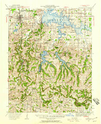
1941 Map of Carbondale
USGS Topo · Published 1955About this map
Crab Orchard Lake dominates the landscape in this 1941 revision, reflecting a period of significant water management in Southern Illinois. The map captures the newly formed reservoirs including Little Grassy Lake and Devils Kitchen Lake, surrounded by the rugged ridges of the Shawnee Hills. To the west, the city of Carbondale serves as a major hub for the Illinois Central Railroad, which cuts south through the village of Makanda toward the orchards of Cobden.
Find a feature on this map
92 named features on this map. Tap any name to fly to it.
Don’t see what you’re looking for? This feature index may not catch every label — zoom into the map to look around manually.
Map Details
Editions of this 1941 Carbondale Map
2 editions found
Other maps of this area

1909 · West Frankfort
USGS Topo · 1:62,500

1910 · Herrin
USGS Topo · 1:62,500

1910 · Murphysboro
USGS Topo · 1:62,500

1918 · Vienna
USGS Topo · 1:62,500

1919 · Vienna
USGS Topo · 1:62,500

1920 · Jonesboro
USGS Topo · 1:62,500

1920 · Dongola
USGS Topo · 1:62,500

1922 · Carbondale
USGS Topo · 1:62,500

1923 · Dongola
USGS Topo · 1:62,500

1923 · Jonesboro
USGS Topo · 1:62,500