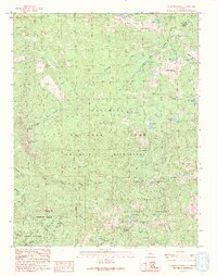
1990 Map of Mariposa Grove
USGS Topo · Published 1990About this map
The giant sequoias of Mariposa Grove anchor this high-country survey of the southern Sierras. This 1990 edition, based on photography from the mid-1980s, documents the intricate landscape of Yosemite National Park and the adjacent Sierra National Forest. Notable landmarks of early conservation and tourism are clearly marked, including the Grizzly Giant and the site of the Tunnel Tree near Wawona Point. The map traces a complex network of backcountry routes such as the Rainier Trail and various pack trails that navigate the steep drainages of the South Fork Merced River and Chilnualna Creek. To the east, the terrain rises toward Buena Vista Peak and the high alpine basins of Ostrander Lake and Royal Arch Lake. Historical extraction efforts are hinted at by the Star Mine and several noted prospects near Raymond Mountain, contrasting with the protected wilderness that defines the region.
Find a feature on this map
40 named features on this map. Tap any name to fly to it.
Don’t see what you’re looking for? This feature index may not catch every label — zoom into the map to look around manually.
Map Details
Editions of this 1990 Mariposa Grove Map
This is the sole edition of this map. No revisions or reprints were ever made.
Other maps of this area

1897 · Yosemite
USGS Topo · 1:125,000

1900 · Yosemite
USGS Topo · 1:125,000

1901 · Mt. Lyell
USGS Topo · 1:125,000

1903 · Yosemite
USGS Topo · 1:125,000

1904 · Kaiser
USGS Topo · 1:125,000

1909 · Yosemite
USGS Topo · 1:125,000

1912 · Mariposa
USGS Topo · 1:125,000

1947 · Mariposa
USGS Topo · 1:250,000

1948 · Mariposa
USGS Topo · 1:250,000

1953 · Merced Peak
USGS Topo · 1:62,500