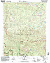
2004 Map of Mariposa Grove
USGS Topo · Published 2007About this map
Mariposa Grove serves as the focal point of this high-elevation landscape, where the Mariposa Big Tree and the famous Grizzly Giant stand within the protected boundaries of Yosemite National Park. The survey illustrates a terrain defined by granite heights like Wawona Dome and Mount Raymond, intersected by the drainage of Chilnualna Creek and its dramatic Chilnualna Falls. Beyond the park's Yosemite Wilderness border, the map transitions into the Sierra National Forest, revealing evidence of earlier human activity such as the Star Mine. This transition area near the Mariposa Co Madera Co line highlights the intersection of federal preservation and resource extraction history. Water is abundant throughout the high country, from the larger Ostrander Lake to smaller alpine basins like Crescent Lake and Dutchman Lake, feeding the South Fork Merced River to the south.
Find a feature on this map
37 named features on this map. Tap any name to fly to it.
Don’t see what you’re looking for? This feature index may not catch every label — zoom into the map to look around manually.
Map Details
Editions of this 2004 Mariposa Grove Map
This is the sole edition of this map. No revisions or reprints were ever made.
Other maps of this area

1897 · Yosemite
USGS Topo · 1:125,000

1900 · Yosemite
USGS Topo · 1:125,000

1901 · Mt. Lyell
USGS Topo · 1:125,000

1903 · Yosemite
USGS Topo · 1:125,000

1904 · Kaiser
USGS Topo · 1:125,000

1909 · Yosemite
USGS Topo · 1:125,000

1912 · Mariposa
USGS Topo · 1:125,000

1947 · Mariposa
USGS Topo · 1:250,000

1948 · Mariposa
USGS Topo · 1:250,000

1953 · Merced Peak
USGS Topo · 1:62,500