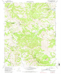
1978 Map of Mariposa Peak
USGS Topo · Published 1982About this map
The rugged boundary between Merced, Santa Clara, and San Benito counties is defined by the sharp elevations of the Diablo Range in this 1960s-era topographic study. Mariposa Peak and Cathedral Peak tower over a landscape marked by legacy mining operations, including the Mariposa Mine, Ambrose Mine, and Stayton Mine. These sites reflect the region's mineral history, while the sprawling Quien Sabe Valley and the Santa Ana y Quien Sabe land grant area emphasize the long-standing ranching traditions of the California interior.
Find a feature on this map
53 named features on this map. Tap any name to fly to it.
Don’t see what you’re looking for? This feature index may not catch every label — zoom into the map to look around manually.
Map Details
Editions of this 1978 Mariposa Peak Map
This is the sole edition of this map. No revisions or reprints were ever made.
Other maps of this area

1919 · Hollister
USGS Topo · 1:48,000

1920 · Pacheco Pass
USGS Topo · 1:62,500

1921 · Gilroy Hot Springs
USGS Topo · 1:62,500

1921 · Hollister
USGS Topo · 1:62,500

1922 · Quien Sabe
USGS Topo · 1:62,500

1922 · San Luis Creek
USGS Topo · 1:31,680

1923 · Hollister
USGS Topo · 1:62,500

1939 · Gilroy Hot Springs
USGS Topo · 1:62,500

1940 · Gilroy Hot Springs
USGS Topo · 1:62,500

1940 · Hollister
USGS Topo · 1:62,500