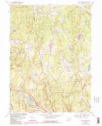
1967 Map of Marlborough
USGS Topo · Published 1985About this map
The town of Marlborough and the village of Gilead anchor this mid-century portrait of central Connecticut’s woodlots and rising residential growth. Dominating the lower portion of the map is Lake Terramuggus, surrounded by a burgeoning network of local roads including Charman Road and Edstrom Road. The landscape is a mix of public lands and small-scale agriculture, with the extensive Salmon River State Forest and Meshomasic State Forest providing a buffer between the surrounding hills. Genealogists will find several burial sites preserved here, from the Old Marlborough Cem near the town center to the remote Burrows Hill Cem. Education is represented by the Macy Hall Sch and Thienes Sch, while the presence of a Lookout Tower and Radio Towers on John Tom Hill marks the highest points in the local topography.
Find a feature on this map
78 named features on this map. Tap any name to fly to it.
Don’t see what you’re looking for? This feature index may not catch every label — zoom into the map to look around manually.
Map Details
Editions of this 1967 Marlborough Map
4 editions found
Other maps of this area

1892 · Hartford
USGS Topo · 1:62,500

1892 · Tolland
USGS Topo · 1:62,500

1892 · Gilead
USGS Topo · 1:62,500

1893 · Middletown
USGS Topo · 1:62,500

1906 · Farmington
USGS Topo · 1:125,000

1921 · Tolland
USGS Topo · 1:62,500

1928 · Glastonbury
USGS Topo · 1:24,000

1928 · Manchester
USGS Topo · 1:24,000

1944 · Manchester
USGS Topo · 1:31,680

1944 · Marlboro
USGS Topo · 1:31,680