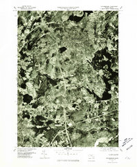
1977 Map of Marlborough
USGS Topo · Published 1981About this map
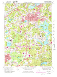
The Marlborough industrial and residential landscape of the late 1970s is captured here through detailed aerial photography. This orthophoto quadrangle provides a direct visual record of the region’s development, showing the dense street grids of the town centers transitioning into suburban subdivisions and major highway interchanges. The expansive Sudbury Reservoir and Fort Meadow Reservoir dominate the hydrology of the area, their irregular shorelines contrasting with the rectilinear patterns of human transit and settlement. Local history researchers can observe the distinct boundaries between Southborough, Southville, and Westborough as they appeared just before the massive tech-sector growth of the 1980s. The visible path of the Sudbury River illustrates how these ancient watercourses remained central to the regional geography even as interstate infrastructure reshaped the modern commute.
Find a feature on this map
7 named features on this map. Tap any name to fly to it.
Don’t see what you’re looking for? This feature index may not catch every label — zoom into the map to look around manually.
Map Details
Editions of this 1977 Marlborough Map
This is the sole edition of this map. No revisions or reprints were ever made.
Historical Maps of Marlborough Through Time
8 maps found