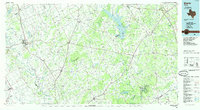
1985 Map of Marlin
USGS Topo · Published 1985About this map
The Brazos River meanders through the western half of this landscape, carving a wide valley that separates Marlin and Rosebud. By the mid-1980s, the region's agricultural roots remained visible through widespread prairie lands like Tidwell Prairie and Bald Prairie, while the newer Lake Limestone dominated the central drainage. The transport network is anchored by a dense system of rail lines, including the Missouri Pacific RR and Southern Pacific RR, which connect old shipping points like Bremond and Franklin. Geologists and local historians can trace the transition from river-bottom lowlands to the elevated terrain of Blue Ridge and Big Hill. Significant local landmarks such as the Marlin Airport and several rural burial sites, including Marlin Cem and Calvary Cem, provide essential anchor points for genealogical research in Falls and Robertson counties.
Find a feature on this map
109 named features on this map. Tap any name to fly to it.
Don’t see what you’re looking for? This feature index may not catch every label — zoom into the map to look around manually.
Map Details
Editions of this 1985 Marlin Map
2 editions found
Other maps of this area

1885 · Taylor
USGS Topo · 1:125,000

1887 · Taylor
USGS Topo · 1:125,000

1892 · Temple
USGS Topo · 1:125,000

1892 · Waco
USGS Topo · 1:125,000

1894 · Taylor
USGS Topo · 1:125,000

1919 · Fairfield
USGS Topo · 1:62,500

1920 · Waco
USGS Topo · 1:125,000

1920 · Mexia
USGS Topo · 1:62,500

1920 · Mart
USGS Topo · 1:62,500

1925 · Iola No 2
USGS Topo · 1:48,000