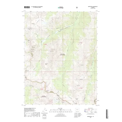
2019 Map of Maroon Bells
USGS Topo · Published 2019About this map
Maroon Bells and the surrounding high-altitude terrain of the Elk Mountains are captured here at the boundary of Pitkin and Gunnison counties. This landscape is defined by its dramatic verticality, featuring notable summits like North Maroon Peak, Pyramid Peak, and Hilliard Peak. The drainage patterns are dominated by Maroon Creek and Conundrum Creek, which carve deep valleys between high ridges such as Len Shoemaker Ridge. A network of high-mountain thoroughfares, including Buckskin Pass, Willow Pass, and West Maroon Pass, suggests a history of transalpine travel through the White River National Forest. For those interested in geothermal features or remote hydrography, the map details Conundrum Hot Springs and alpine water bodies like Crater Lake and Willow Lake. The presence of the Maroon Snowmass Trail and the Copper Pass Spur highlights the long-established route systems used to navigate this glaciated environment.
Find a feature on this map
46 named features on this map. Tap any name to fly to it.
Don’t see what you’re looking for? This feature index may not catch every label — zoom into the map to look around manually.
Map Details
Editions of this 2019 Maroon Bells Map
This is the sole edition of this map. No revisions or reprints were ever made.
Other maps of this area

1888 · Crested Butte
USGS Topo · 1:62,500

1888 · Anthracite
USGS Topo · 1:62,500

1889 · Crested Butte
USGS Topo · 1:62,500

1889 · Anthracite
USGS Topo · 1:62,500

1893 · Anthracite
USGS Topo · 1:62,500

1893 · Crested Butte
USGS Topo · 1:62,500

1893 · Aspen
USGS Topo · 1:62,500

1894 · Anthracite
USGS Topo · 1:62,500

1895 · Aspen
USGS Topo · 1:62,500

1909 · Mount Jackson
USGS Topo · 1:125,000