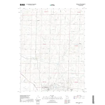
2017 Map of Marshall North
USGS Topo · Published 2017About this map
Marshall anchors the southern edge of this Saline County landscape, where the urban grid gives way to the agricultural expanses of the northern Missouri plains. The northern sections are defined by small crossroads settlements like Fairville and Norton, connected by a network of rural routes such as State Hwy 122 and the historic path of the Santa Fe Trl. This area is heavily dissected by the winding drainage of the Salt Fork, which feeds into localized water bodies including Bryan Lake and the Marshall Habilitation Center Lake. Genealogists and local historians will find value in the location of the Odell Cem and named landmarks like Montague Hill. The map illustrates a contemporary pattern of land use, balancing the growth of the county seat with preserved rural tracks and the natural flow of the Cow Cr and its many branches.
Find a feature on this map
55 named features on this map. Tap any name to fly to it.
Don’t see what you’re looking for? This feature index may not catch every label — zoom into the map to look around manually.
Map Details
Editions of this 2017 Marshall North Map
This is the sole edition of this map. No revisions or reprints were ever made.
Other maps of this area

1890 · Marshall
USGS Topo · 1:125,000

1892 · Marshall
USGS Topo · 1:125,000

1901 · Marshall
USGS Topo · 1:125,000

1940 · Marshall
USGS Topo · 1:62,500

1944 · Marshall
USGS Topo · 1:62,500

1951 · Miami
USGS Topo · 1:24,000

1951 · Miami Station
USGS Topo · 1:24,000
1951 · New Frankfort
USGS Topo · 1:24,000

1953 · Moberly
USGS Topo · 1:250,000
1953 · Shackleford
USGS Topo · 1:24,000