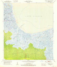
1951 Map of Martello Castle
USGS Topo · Published 1952About this map
Martello Castle stands as a lonely landmark overlooking the expanse of Lake Borgne, marking the strategic coastal defenses of the St. Bernard Parish and Orleans Parish boundary. This mid-century survey captures a complex delta landscape where the freshwater drainage of the Lake Borgne Canal and the New Canal meets a dense network of tidal waterways. The mapping reveals a transition from inland marsh to open water, defined by a labyrinth of winding channels such as Bayou Bienvenue, Bayou Dupre, and Bayou Chaperon. Near the southeastern edge, Shell Beach and Bayou Shell Beach indicate the tenuous shoreline before the coastal erosion of later decades significantly altered these wetlands. The intricate system of bayous, including Grand Bayou and Mosquito Bayou, illustrates the natural hydrology of the region as it existed during the early 1950s, supporting local livelihoods centered on the gulf waters and marshes.
Find a feature on this map
23 named features on this map. Tap any name to fly to it.
Don’t see what you’re looking for? This feature index may not catch every label — zoom into the map to look around manually.
Map Details
Editions of this 1951 Martello Castle Map
2 editions found
Other maps of this area

1892 · Chef Menteur
USGS Topo · 1:62,500

1892 · St. Bernard
USGS Topo · 1:62,500

1893 · Rigolets
USGS Topo · 1:62,500

1893 · Shell Beach
USGS Topo · 1:62,500

1935 · Delacroix
USGS Topo · 1:31,680

1936 · Chef Menteur
USGS Topo · 1:62,500

1936 · Rigolets
USGS Topo · 1:62,500

1937 · Chef Menteur
USGS Topo · 1:31,680

1938 · Little Woods
USGS Topo · 1:31,680

1939 · Shell Beach
USGS Topo · 1:62,500