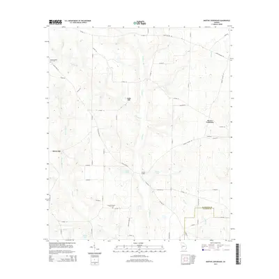
2014 Map of Martins Crossroads
USGS Topo · Published 2014About this map
Pachitla Cr meanders southward through this rural corner of Southwest Georgia, defining a landscape traditionally shaped by water and small milling settlements. The area is anchored by historic sites such as Goffs Mill and Shivers Mill, which indicate the long-standing reliance on local creek systems like Goffs Mill Cr and Shivers Mill Cr. The map reveals a network of country roads, including Robinett Factory Rd and Aycock Mill Rd, which connect scattered farms to the central hub at Martins Crossroads. For genealogists, the presence of the Damascus Baptist Church Cem and New Bethel Baptist Church Cem provides critical points for family history research. This survey illustrates the persistent rural character of the Randolph Co and Calhoun Co border, where private agricultural lands are interspersed with water features like Williams Lake and Bridges Lake.
Find a feature on this map
60 named features on this map. Tap any name to fly to it.
Don’t see what you’re looking for? This feature index may not catch every label — zoom into the map to look around manually.
Map Details
Editions of this 2014 Martins Crossroads Map
This is the sole edition of this map. No revisions or reprints were ever made.
Other maps of this area

1953 · Dothan
USGS Topo · 1:250,000

1954 · Dothan
USGS Topo · 1:250,000

1955 · Dothan
USGS Topo · 1:250,000

1972 · Shellman
USGS Topo · 1:24,000
1972 · Brooksville
USGS Topo · 1:24,000
1972 · Cuthbert
USGS Topo · 1:24,000

1973 · Morgan
USGS Topo · 1:24,000

1973 · Martins Crossroads
USGS Topo · 1:24,000
1973 · Doverel
USGS Topo · 1:24,000

1973 · Edison
USGS Topo · 1:24,000